Metre by metre, the longest bridge on the ‘greenfields’ Transmission Gully Motorway project north of Wellington is being incrementally launched across Cannons Creek. RICHARD SILCOCK reports on progress.
IMAGES BY MARK COOTE PHOTOGRAPHY UNLESS MARKED OTHERWISE
At 230 metres long and 24.5 metres wide, the Cannons Creek Bridge is by far the longest bridge to be constructed along the 27-kilometre, $850 million Transmission Gully Motorway (TGM) which is expected to open next year following five years of extensive construction.
Cannons Creek Bridge Technical facts:
• 230 metres long and 24.5 metres wide
• 60 metres high above the gully floor
• It will comprise three spans
• The 44 reinforced steel beams are between 17-24 metres long and weigh between 37-70 tonnes each
• The bridge beams and deck will be supported on two, 24 metre high reinforced concrete piers
• 10,000 cubic metres of concrete was used for the bridge foundations
• 38,000 bolts will be used to connect the beam sections
• ‘Robson’ rotating bearing units will allow the structure to flex and withstand seismic movement
• Time to construct: Two years
When completed, bridge 20 as it is known by contractors, will tower 60 metres above the gully it spans and will carry traffic over two lanes in each direction.
According to an NZTA spokesperson, this three-span bridge will be a showcase of technical design and innovation, as it presents a number of technical challenges associated with constructing a long, high and curved bridge that is aesthetically pleasing yet able to withstand a 1-in-2500 year seismic event.
The motorway and the infrastructure along it are being constructed by a JV comprising CPB Contractors and HEB Construction under a PPP contract with the Wellington Gateway Partnership for NZTA.
JV structures manager, Rudolf Joubert, says the geographical features of Cannons Creek gully, which is heavily vegetated, very steep and quite wide, made access very difficult. In addition there are high tension power lines stretching across the gully.
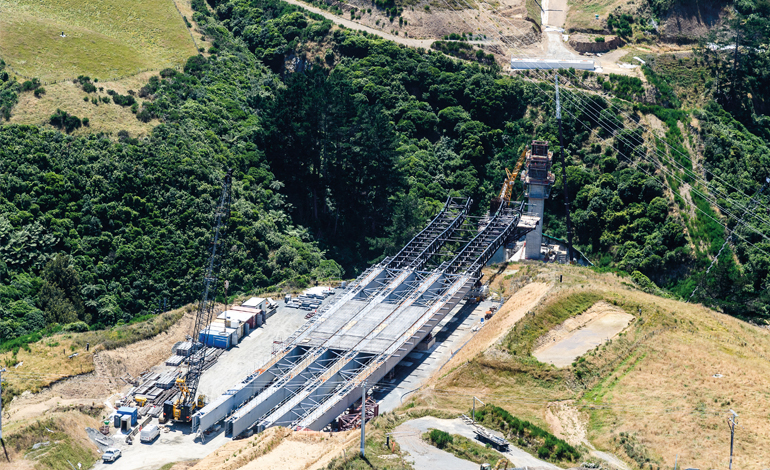
“For this reason the bridge superstructure is being constructed by launching pre-fabricated steel beam sections out and across the gap between the bridge piers and the abutments,” says Rudolf.
The launching equipment was imported from China several months ago. It comprises a custom-made lightweight steel ‘nose’ frame, steel rocker skids to assist the forward movement of the beams as they are pulled across and brake pistons to hold the launched sections in place during the trajectory phases.
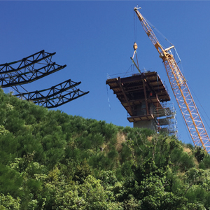
Prior to the launch stage, considerable work, both onsite and off-site has been ongoing. Shotcrete retaining walls were constructed on the steep banks adjacent to the pier sites excavations, huge concrete foundation blocks poured and two, 24 metre high reinforced concrete piers built which are topped by 660 tonne crossheads. The piers are socketed to the foundations to a depth of 12 metres (refer Contractor April 2018). Over 24,000 cubic metres of concrete was used in constructing each pier and foundation.
The 44 reinforced steel, 17-24 metre-long bridge beams were all pre-fabricated in Napier by Eastbridge Ltd using 350MPa yield strength mild steel.
Andre van Heerden, general manager for Eastbridge, says the beams were fabricated to within several millimetres tolerance and the steel used was quality tested by an independent lab for both mechanical and chemical compliance.
He says each beam took around two weeks to fabricate and required around 3000 tonnes of steel.
The beams were trucked to site by Hawke’s Bay based heavy-haulage operator Tomoana Transport and it took a total of 44 trips to get all the beams to site on the southern side of the gully.
Here the beams were assembled on the steel skids and ganged together in sections. The first section being launched comprises five beam lengths bolted together end-on-end and replicated four times across the width.
There are four sections or launch phases and a sequence of steps and checks are taken before launching each section. With the ‘nose’ frame attached to the front end of the first section this entire structure is very slowly pulled by a series of horizontal, front mounted hydraulic strand jacks out and across to the first pier.
This sequence is repeated with the other three sections until the first section reaches the abutment at the opposite (northern) bank of the gully where the nose structure will be removed and the beams bolted in position.
Each section of the bridge as it is launched is counter-balanced by the remaining sections at the launching site and each is unique by way of differing lengths, sweep, camber and elevation The longest, first section is 86 metres, with the other two 74 and 68 metres long, this being the distance between the piers and the abutments. The curvature of the bridge has a radius of 1100 metres.
To aid the launch and facilitate a smooth trajectory, large teflon rubber pads lubricated with grease are used between the undersides of the beams and the skid interfaces, with the rate of trajectory moving at around eight metres per hour.
“Due to the complexity of this launching phase, we carried out a series of ‘tests’ prior to Christmas to ensure the structure ‘behaves’ as determined by our computer modelling,” says Ian Pringle, a senior project engineer working on the bridge construction.
“Apart from some minor tweaking it is exactly as we calculated.”
Asked about the challenges of building a bridge in this manner, Ian says it has been pretty straightforward so far, with the weather being the only concern.
“We can’t launch if the wind exceeds a certain strength, or if there is torrential rain, so we will be keeping an eye on the weather forecasts as we progress,” he says.
“Another interesting aspect is the amount of man-power required to manually ‘feed’ the teflon ‘lubricating’ pads between the beams and the skid interfaces as we launch forward.
“Up to 60 people are required to do this.”
The beam sections are attached to the pier crossheads using special ‘Robson’ rotating bearing units which allow the bridge structure to flex and withstand seismic movement. These bearings are connected to the beams by a series of large bolts and to the pier crossheads and abutments by cast-in concrete high-strength threaded steel bars.
The entire launching sequence, which commenced last month is expected to take eight-months to complete.
Once complete and the beam sections are attached to the pier crossheads the reinforced concrete deck will be poured, side barriers installed and the bridge jointed at both ends to the road ready for paving.
Work in progress
By the end of the current summer season the earthworks for the project will essentially be completed and sections of the motorway base course and initial surface layers should be well advanced, with the project entering the final stages of construction.
As previously reported, (refer Contractor May 2017 and April 2018) the construction of this ‘greenfields’ motorway has progressed at various sites simultaneously and has involved some nine million cubic metres of earthworks. Over 900 people working in shifts have clocked up over five million work hours.
From the air the motorway alignment can be seen to its full extent as it carves it way through the countryside and according to project director for construction, Justin Redelinghuys, work is well advanced across all sites.1
At the southern end, where TGM connects with the Wellington- Porirua Motorway near Linden, a two-lane on-ramp and bridge is currently under construction. This will carry north-bound traffic and branch off a new left-hand lane of the Wellington-Porirua Motorway and then cross, via the bridge (bridge 25) back over it to link with TGM. This bridge is expected to have beams in place this month with construction completed by August. Southbound traffic from TGM will merge with the Porirua-Wellington Motorway south- bound lanes via an embankment and slip-lanes, which are under construction.
At Pauatahanui, SH58 (Hutt to Paremata) has been realigned and an over-bridge (bridge 13) is nearing completion. This bridge, which will carry TGM over SH58, was constructed using 13 super-tee beams, each weighing 64 tonnes. Three other bridges are being built here to take the motorway and on/off ramps over the Pauatahanui Stream.
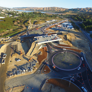
A series of roundabouts have been completed as part of this interchange. These allow traffic on SH58 to branch off in three directions, and will include access to/from TGM. The intersection has been built a metre above the current road level in order to raise it above the Pauatahanui Inlet tidal flood plain.
Where the motorway will join the Kapiti Expressway at Mackays Crossing (northern end), considerable ground improvement work has been completed and the current SH1 alignment leading to/from Paekakariki has been realigned to allow unhindered construction of a bridge (bridge 3) and the TGM alignment. Once TGM is complete this SH1 realignment will become the northbound connection from the coastal route.2
Despite some local concerns over sediment runoff affecting the nearby Whitby Lakes, which is thought to have come from construction of a local link road, there have been no environmental incidents caused by the project to date and Redelinghuys says in a press report that all work on the TGM project itself has exceeded the resource consent conditions.
In August last year the project was awarded the coveted IECA Environmental Excellence Award in recognition of the world leading technique used diverting the Te Puka and Horokiri Streams (refer Contractor April 2018).


