What lies beneath …? Noggin 1000 GPR systems are regularly used for shallow, high resolution imaging on and around building infrastructure, but sometimes, during a survey, you may find something totally unexpected.
 DURING A RECENT GPR training course in Christchurch, everyone in the class, including the trainer, was shocked to find what was revealed by GPR. The class was learning how to set up and collect data with a Noggin 1000 system using the SmartHandle configuration.
An empty warehouse near the training room was undergoing an extensive refurbishment after the severe earthquake that struck the area in 2011. The building owners allowed the class to use the open 20×30 metre warehouse area as a test site for the GPR training course.
The project started by collecting a few long reconnaissance lines across the floor in both directions to get a ‘feel’ for the construction practice and reveal any large-scale anomalous areas. This showed that wire reinforcing mesh was present in less than half the floor. The line also revealed a strong hyperbolic response below the slab-on-grade concrete floor, initially interpreted at the time as a pipe or cable.
The next part of the training was grid collection so, based on what the reconnaissance lines had shown, a detailed grid survey was carried out over the ‘pipe’.
The grid data was processed and visualised as a series of depth slices using the SliceView module in the EKKO Project software. In seconds everyone realised that the ‘pipe’ interpretation was not correct. The 0.40 metre depth slice revealed there were two parallel, linear objects crossing underneath the warehouse floor.
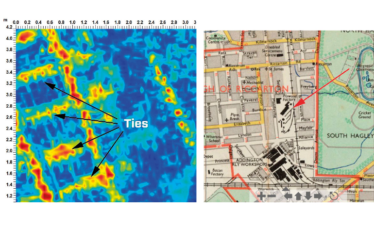
Slicing deeper to 0.55 metres revealed linear features at equal intervals running between and perpendicular to the two parallel linear objects. Someone in the class suggested that it was a buried ladder until they used the SliceView Measure Tool to measure the width of the ‘ladder’ at 1.15 metres and the distances between the ‘rungs’ at 0.70 metres – an awfully large ladder!
Finally someone suggested it looked like railroad tracks with ties between them. Sure enough, the measurements were consistent with the gauge of New Zealand railroad tracks. A couple of minutes later, a computer-savvy student hopped on the internet and found an old map in the Christchurch archives that showed a railroad track had once run through the area.
Once the interpretation of railroad track was made, a few other pieces of the puzzle fell into place. Not noticed initially during the data collection, but discovered after closer inspection of the reconnaissance lines, was the wire mesh-like response beside the strong ‘pipe’ hyperbola. This mesh pattern can also be seen in the 40 centimetre depth slice (Figure 2). The mesh seems to be related to the railroad track, perhaps the concrete platform it rests on.
This survey just goes to show that, while many applications for GPR are routine (looking for buried pipes, cables and rebar), every now and then you find something you were not expecting.
- Story and data courtesy of Lord Civil, Christchurch.

