Construction work on the $2.1 billion, 102 kilometre-long Waikato Expressway is, according to the NZ Transport Agency, ramping up and moving along and is pretty much on schedule for completion by early 2020. By RICHARD SILCOCK.
STARTING AT THE intersection of SH1 and SH2 on the southern side of the Bombay Hills, the divided four-lane Waikato Expressway will finish just south of Cambridge in central Waikato. It is the most expensive and largest road construction project undertaken in New Zealand in the past decade and has been a priority of the region’s land transport initiatives for some considerable time.
First mooted in the late 1950s, feasibility studies were undertaken by the Ministry of Works, with the route originally designated in 1963. Following amendments in the late 1990s by Opus International Consultants (Opus) and Bloxam, Burnett and Olliver (BBO) construction of various sections of SH1 were completed at Pokeno, Mercer, Ohinewai and Tamahere during the early 2000s. In 2009, an expressway strategy was adopted by NZTA and it was advanced as a Road of National Significance (RoNS) in the same year following the National government’s policy statement and report, The Regional Land Transport Funding Strategy.
The major part of the expressway is being built in seven sections by a consortium of various contractors and consultants working to a variety of contract packages. From north to south these sections comprise: Longswamp, Rangiriri, Huntly, Ngaruawahia, Te Rapa, Hamilton and Cambridge.
NZTA’s Hamilton based highways manager, Kaye Clark says the expressway is being constructed in sections in accordance with the designation and consenting process associated with a project of this size and magnitude.
“Many of the original [SH1] sections began as individual projects with some investigation and design work already underway before it was elevated to an expressway and a RoNS,” says Kaye. “By continuing to work in sections, it has allowed us to stage the construction and help suppliers [the contracting and consulting industry] balance their resources. We have procured each section on the basis of the supplier or consortia being able to deliver a best fit-for-purpose job. Some sections are being delivered as design and construct contracts, while others are competitive alliances.
“It is designated an expressway as it essentially comes with a slightly different set of standards than say the Auckland Motorway which has restricted stopping and on/off ramps. All current sections of the expressway have interchanges, while some of the earlier sections have roads linking at meeting points.”
The first part of the expressway to be completed as a RoNs was the eight kilometre Te Rapa section known as Mangaharakeke Drive. This was completed in December 2012 in a competitive alliance comprising NZTA, Opus and Fulton Hogan. It includes six bridges, one of which passes over the main trunk railway line, and connects at Horotiu with the 12.3 kilometre Ngaruawahia section, which was completed in December 2013 under a design/construct contract comprising Fletcher Infrastructure, Higgins Construction and Beca. It includes five bridges, one of which crosses the Waikato River. Traffic is now using both these sections.
Earthworks at Rangiriri are now well underway with Fletcher Infrastructure and MWH Global as design consultants contracted under an early contractor involvement model. This section comprises realigning and widening to four lanes over 4.8 kilometres of SH1 and creating a new alignment west of the town and the historic Rangiriri Pa site. It will include the construction of two bridges, one at the Te Kauwhata Interchange and the other at the Rangiriri Interchange and is expected to be completed in early 2017.

Fletcher’s project manager, Charles Stokes says the earthworks for this section have proven to be the most time-consuming aspect of the job due to the variable geotechnical conditions of the ground, the need for long settlement periods where large embankments overlay soft alluvial deposits, and the close proximity to the Waikato River, Lake Waikare and the township of Rangiriri.
“The expressway runs down a very narrow corridor of land between the river – which is only 50 metres away in parts – and the lake,” says Charles. “Due to the high water table and soft alluvial flood plain deposits at the southern end, we had to adopt a number of ground improvements including stone columns, drainage blankets and a high number of wick drains. “Around 16 kilometres of stone column has been installed at both the Rangiriri Interchange and for a multiplate culvert structure that spans the historic site. The mid-section is pretty much rolling countryside with a number of shallow gullies which we are now filling.”
He says this section has required some 900,000 square metres of earthworks for which they have been using mainly Hyundai 12-40 tonne excavators and 30-40 tonne articulated dump trucks, along with a number of earth scrapers, working six-day weeks when the weather permits. In addition to the road formation, there will be a commemorative area created at the Rangiriri Pa.
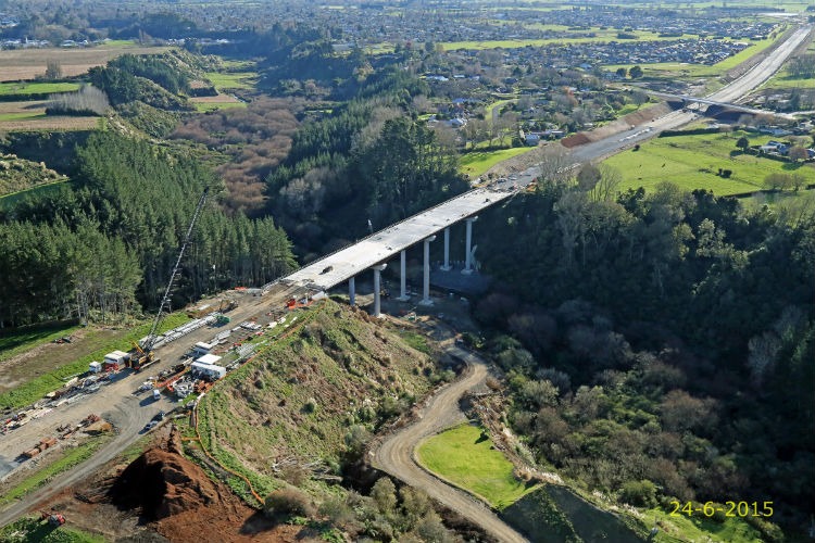
The 16 kilometre Tamahere to Cambridge section is being undertaken by HEB Construction, with consultants URS and Opus providing the engineering design and advisory services. It is expected to be completed by the end of this year and has eight bridges including a 200 metre-long, 40-metre high viaduct across the Karapiro Gully, just north of the lake. Another bridge is being built to allow horses to safely cross the expressway.
Project manager for HEB Construction, Gary Budden says the viaduct has been challenging to construct due to its height above the gully and the depth of the piles.
“The viaduct is the most unusual aspect of this section,” he says. “It has taken 20 months to construct and has required 1200 tonnes of high-tension structural steel, 23,000 bolts and 12,000 tonnes of pre-cast concrete. Foundations for the three twin support pylons – each column is 2.7 metres in diameter – required 64 piles to be driven to a depth of between 30 and 69 metres. Around 1185 cubic metres of concrete alone is being poured for the deck, which will be covered with open-graded porous asphalt to form the road pavement. Expanding modular deck joints have also been installed at each end of the viaduct to allow for temperature expansion and heavy loading.”
Construction by joint-venture partners Fulton Hogan and HEB Construction on the 15.2 kilometre, $458 million Huntly section will start in September this year, with Opus and Jacobs Design providing design services. Gaia Engineers and Bartley Consultants are providing specialist subcontracting services, and BBO will act as the client’s representative.
Fulton Hogan and HEB joint venture project manager, Tony Dickens says the most challenging aspect of this section will be the rugged nature of the ground which comprises greywacke, various types of clay, sand, volcanic deposits, peat and old coal mine tailings from the Huntly East mines.
“The expressway skirts Huntley, running to the east of the town and will entail almost four million cubic metres of earthworks and an 80-metre deep cutting through the Taupiri Range,” says Tony. “We will utilise over a million cubic metres of the cut material as fill elsewhere and we expect it will take three years to complete. Due to the depth of the cutting, tiered battered terraces will be constructed, and the road gradient will be between 3.5 percent to a maximum of six percent.
“This section will see the construction of two half-diamond interchanges and nine bridges, four of which will cross tributaries of the Waikato River,” he says. “The other four bridges will carry roads over the expressway, while the other will cross the railway line. Again, due to the nature of the ground, we will be driving 60-metre deep piles for the foundations. These bridges will be constructed using weathering steel and pre-stressed concrete.”
As this section of the expressway crosses important historical sites (including pre-European, Maori borrow/storage pits and remnants of what was a large horticulture area) and significant ecological habitats, NZTA and its design consultants built strong relationships with local iwi during the planning stages of the project. This resulted in a cultural mitigation plan being developed and agreed by Waikato Tainui to ensure ongoing consultation is maintained throughout the construction period.
In keeping with this plan will be the installation of pou whenua, while several of the bridges will feature reliefs of awa and native wildlife found in the area. In addition there will be enhancement of 100 hectares of forest and native bush habitat, landscaping and restorative planting of wetlands, replanting along parts of the river and the preservation of several historic pa sites (Otaahau and Te Uapata).

Archaeologists will be assisted by an iwi archaeologist to record and preserve any significant ‘finds’ while a kaiarahi will work alongside the construction team as a cultural monitor. This consultative approach has resulted in NZTA and consultants BBO being awarded the NZ Planning Institute’s 2015 Nancy Northcroft Best Practice Award.
“Through this close collaboration and engagement with iwi and other key parties throughout the development stages of this section we have not required any RMA consent hearings,” says Kaye Clark. “And there has been only one brief hearing to finalise the designation conditions.”
Waikato Tainui CEO, Parekawhia McLean says she is pleased NZTA actively engaged tribal members in all areas of the Huntly section.
“The involvement of our people in this aspect of the project is of great importance to the tribe,” she says. “We established a working group of marae representatives so that we could engage with the agency, its contractors and with the project’s archaeologists, whose recent ‘finds’ reaffirm our historical connection to this land. We are the direct descendants of the early Maori who settled in this area – they are our ancestors.”
Huntly will be followed by the 21.8 kilometre Hamilton section under a competitive alliance contract. Two consortia have been selected to bid for this work and tenders are expected to be announced in October. This section will include 15 bridges across various steep gullies along with large scale earthworks and an interchange at the southern end.
The last section to be constructed will be the 5.9 kilometres at Longswamp which is expected to be tendered in early 2016 and will entail widening the existing SH1 to four lanes and providing improved local road connections via an overbridge.
Kaye Clark says all the contractors are complying with the development and implementation of a range of compliance and mitigation plans and have fostered good relationships with local communities, land owners and regional authorities.
The progress of the expressway has been welcomed by the region’s civic leaders, who all say it will provide for increased traffic capacity well into the future, greater safety with the separated carriageway and that it will help stimulate economic growth and productivity in the agricultural, tourism and business centres of the Waikato and Bay of Plenty regions.
When complete, the expressway will shave around six kilometres off the old SH1 route and replace it as the key transport corridor for traffic through the Waikato region. Fuel savings and journey times for motorists and freight companies will be greatly reduced with time savings expected to be in the region of 35 minutes with the traffic congestion that was experienced on SH1 at the ‘pinch points’ of Huntly, Ngaruawahia, Hamilton and Cambridge alleviated.
While a large proportion of the expressway is ‘greenfields’ construction, parts of SH1 are being utilised, upgraded and widened. Those parts of the old highway that remain will be re-designated local roads and given a new name, while other parts may possibly become cycle-ways. NZTA say there are no plans to toll the expressway, and while there is no intention to add additional lanes in the foreseeable future there is sufficient road reserve to accommodate an additional lane in each direction should it be needed.
Parting words from Jeremy Sole- a final column