To the arriving colonists at the top of the South Island, Takaka Hill represented a major obstacle between the cramped and land-hungry settlement of Nelson, and the promising lower reaches of the valleys of the Takaka and Aorere Rivers. HUGH DE LACY tells how it was conquered.

To the settlers in the region, Takaka Hill was a major, if not awesome, obstacle between two valuable regions – the cramped and land-hungry settlement of Nelson, and the promising lower reaches of the valleys of the Takaka and Aorere Rivers.
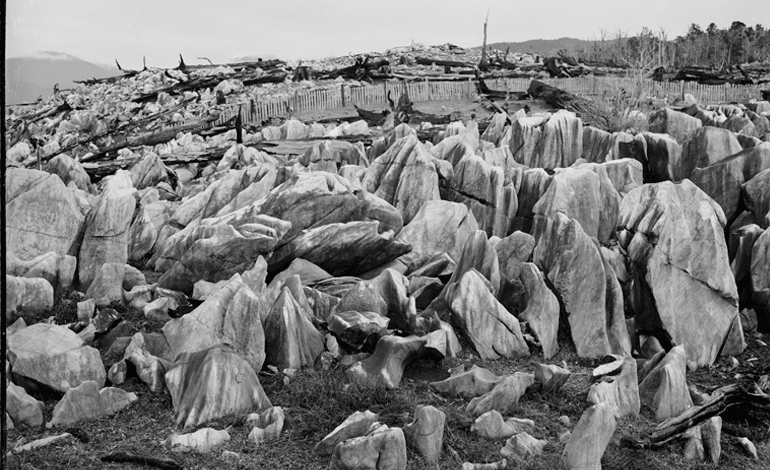
The topography of the Takaka Hill is classic karst, named after a similar marble structure near Trieste in northern Italy, and formed by the dissolving of rocks such as limestone, dolomite and gypsum.
This process leaves funnel-shaped tunnels called dolines, and sink-holes and caves around the non-soluble rock in the structure.
The first non-Maori to traverse the hill is thought to have been Charles Heaphy, the artist and inveterate explorer aboard the New Zealand Company’s (which founded Nelson, Wellington and New Plymouth) first immigrant ship Tory. He later earned the first Victoria Cross for gallantry awarded to a British colonial soldier during the Waikato Land Wars in the 1860s. Heaphy, who was farming in Nelson at the time, crossed the Takaka massif in 1843.
He was later part of two great exploratory journeys of the South Island, the first with a Maori guide called Kehu, and William Fox up the Buller River, and the second with Thomas Brunner through south Westland.
At first the only way for the settlers to get to what are now the towns of Takaka and Collingwood was by ship around Separation Point, where the massif juts out into Golden Bay.
A gold rush on the Aorere River south of Collingwood in the early 1850s saw a foot-track, called the Pikikiruna Track, hacked across the Takaka Hill.
It was slowly widened and improved, but it was not until the 1870s that work began on upgrading it first to a bridle path, and eventually to a metalled road suitable for coaches.
This came about following agitation by the Bate brothers, Daniel and Henry, who farmed the Upper Takaka, and it was they who did the initial work on it under contract to the local council.
Planning for the upgrade to coach standard didn’t begin until 1886.
It followed a different route to that of the Bates’ contract, one that reduced the gradient on the Takaka side from 12-to-1 to 16-to-1, thereby defeating calls for the road to follow the coast, which would have been three times as long.
Bates’ track crossed the new road, which was not completed until 1900, in several places, and continued to be used for some time after.
Once work was begun on the road it progressed quickly, and on January 3, 1888, two buggies assailed it from the Takaka side, taking just three hours to get to the top then two more down to Riwaka.

The road not only opened up the Takaka and Aorere valleys for farming, but also allowed a marble mine to be established on the hill-top at Kairuru, 10 kilometres from Riwaka, which developed a name for quality stone used in the construction industry around the turn of the century.
The Government Architect, John Campbell, specified Takaka marble for the construction of Parliament Buildings from 1911, because it was strong and it could be polished to a bright creamy lustre.
A 10.4 kilometre tramline was formed to cart the big blocks of marble down to Sandy Bay, north of Kaiteriteri, from where they were shipped to Wellington.
By the time Parliament Buildings was completed in 1922, 5000 tonnes of marble had been quarried from Kairuru.

Takaka marble is still available today, though from the Kairuru quarry in the Holyoake Valley, up the hill from Riwaka.
The modern road still follows the course of the one completed in 1900, and though it is less than 60 kilometres from Riwaka to Takaka, the winding and precipitous route takes a good hour to drive.
It’s a spectacular drive though, with features like the eerie karst formations on the Canaan Plateau on the top, and Harwood’s Hole, once thought to be the deepest in the country, hidden away by massive cliffs, but both accessible to motorists.
The drive from the top down to Takaka covers only about 10 kilometres, but it’s a series of savage switchbacks, and the steepness of the descent that cuts speed to a minimum.
Some 200 years on, the taipo, the goblin, still bellows up through the caverns and tunnels deep in the mountain, but it’s with a benign voice now, and its song is for travellers rather than refugees from Te Rauparaha.
Marble Mountain for good reason
The massive Takaka Hill, dividing Nelson and Golden Bay at the top of the South Island, is better known to locals as Marble Mountain for good reason – it is almost solid marble. State Highway 60 weaves a tortuous

path over this hill, cutting through ancient craggy lime and marble formations coloured a grey/black with algae. As the road nears the Ngarua Caves below the summit on the Nelson side, it passes an old green building that houses the crushing plant of the Ngarua Lime quarry, owned by Ravensdown.
Ngarua Lime quarry sits on precipitous farmland a little further up the hill from a more famous quarry, Kairuru, which gained national prominence in 1911 when it was chosen for marble used in the construction of the new Parliament Buildings in Wellington, and again in the 1990s when the building was renovated.
It wasn’t just the construction industry that sought Takaka marble; the crushed calcium carbonate (whites) ended up in cosmetics, household cleaners, toothpaste, paint, glass, paper manufacturing (up to 40 percent of paper is calcium carbonate), and even the health supplement industry.
DAROUX, LOUIS JOHN, 1870-1948: PHOTOGRAPHS OF NEW ZEALAND AND THE PACIFIC. ALEXANDER TURNBULL LIBRARY, WELLINGTON.
Parting words from Jeremy Sole- a final column