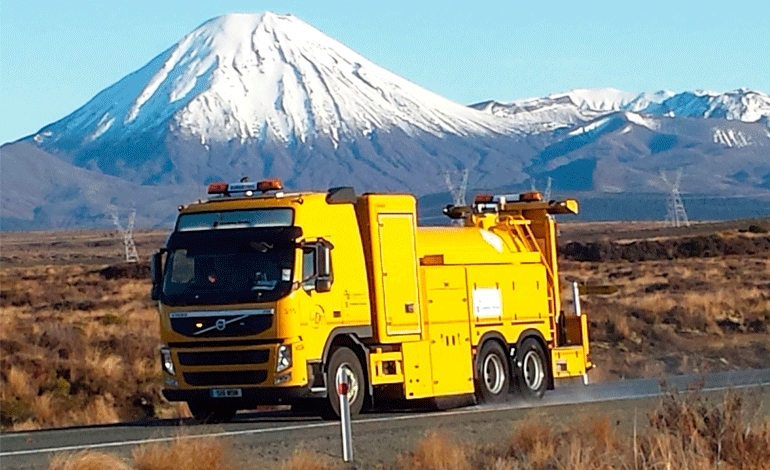
The SCRIM trucks were back on our highways over the summer, with the last surveying completed over the lower North and South Island regions in January. Alan Titchall explains why this surveying has become so vital to maintaining and modelling our highway network.
SCRIM is the acronym for quite a mouthful – ‘Sideway-force Coefficient Routine Investigation Machine’. The distinctive yellow coloured trucks are commissioned by the Transport Agency and have become a feature on our roads in past summers as they travel our networks at 80 kilometres per hour collecting pavement information – skid resistance; texture; roughness; rutting; geometry (gradient, crossfall and curvature); and centreline GPS coordinates.

In addition to ‘responding’ to found defects, the NZTA uses the data to monitor highway performance; plan future work programmes; analyse trends; and predict how road conditions might change in the future. Information is stored in the agency’s RAMM database and used for many aspects of network modelling.
The 2 SCRIM vehicles are unique to this country having been designed to deliver data as required by NZTA. They are built and supplied by Bristol-based WDM, a large manufacturer and provider of highway survey and monitoring equipment, and the largest survey contractor in the UK, serving all UK government agencies and 90 percent of local authorities. It also carries out work in South Africa and Australia, amongst other overseas markets, and has been surveying our own roading network every year since 1995, with a focus on the Transport Agency and local authorities.
The surveying is said to be very accurate. The trucks are sent back to the UK each year for a complete overhaul of the technical equipment and every nut and bolt on the truck. Collected data also goes through multiple validation checks for accuracy. John Donbavand, National Pavements manager at NZTA, calls it the “largest validation programme in the world”, with the machines put through rigid ‘repeatability’ tests using comparative data.
The GPS systems on these trucks mean the Transport Agency can match 20-metre segments of road between different years, he says.
During 2014-15, he adds, the NZTA had two SCRIM trucks take part in repeat tests on the same section of road in Central Otago to compare data for accuracy, and with satisfying results.
The technique

While the truck is on the move, a bar with 20 lasers defines the transverse profile over a road width of 3.3 metres. The rut depth in each wheel-path is calculated from this transverse profile using a simulated two metre straight edge. This data is used to determine the average, maximum and minimum rut depth, and the standard deviation and the distribution of rut depths every 20 metres.
Longitudinal profile (roughness) is measured using two lasers, one in each wheel-path, together with accelerometers fitted on the transverse beam. Vehicle suspension effects are defined by the accelerometers and deducted from the laser output to provide a road profile. The International Roughness Index (IRI) is calculated from the longitudinal profile using the World Bank Quarter Car model and, again, is reported every 20 metres.
Road Texture is measured by three 32 kilohertz lasers, one each in the left and right wheel-paths and one between the wheel-paths. Accelerometers remove most of the vehicle motion relative to the road to provide a stable inertial profile from which the MPD (Mean Profile Depth) is calculated. This MPD is also measured and calculated according to ISO 13473-1:1997.
Survey equipment features a geometry measurement system using inclinometers and gyroscopes to sense the vehicle attitude as the truck travels along the road. Inclinometers measure the forward or back tilt of the vehicle for gradient, and the side-to-side tilt of the axles for crossfall. Gyroscopes are used to sense the movement of the vehicle around corners to calculate the horizontal and vertical curvature. Geometry data is smoothed with a 30-metre moving average and reported at every 10 metres.
Oxford Technical Solutions GPS equipment samples the Omni-Star satellite to record the differential GPS coordinates of the centre-line. Tilt sensors for cross-fall and gradient, together with a gyroscope, provide alignment details when out of sight of the satellite. Information is post processed using LINZ base stations.
The survey data, including forward facing video is then sent back to WDM’s offices in Wellington where it is processed, fitted to the NZ roading network and verified before being issued to NZTA. High data integrity standards are applied to ensure that the clients can rely on the SCRIM measurements in making investment decisions.
Skid resistance – the Holy Grail of safe roads
Skid resistance is a vital feature of road safety in a country such as New Zealand with its abundant rainfall, ice, snow, and surface water during heavy rain which is thrown into the face of oncoming traffic by our trucks.
WDM even promotes its work on skid resistance in New Zealand on its website. “The wet skid injury crash rate on road sections with ‘low’ skid resistance is 4.5 to nine times greater than that for all roads,” the company says.
“Results of crash site analysis indicate that a 0.1 increase in skid resistance (measured in terms of Mean Summer SCRIM Coefficient, MSSC) causes a reduction in injury crashes of 30 percent on wet roads and 20 percent on dry roads for the New Zealand state highway network. Overall, since SCRIM surveys were introduced, the number of skid-related fatalities in New Zealand has fallen by nearly 40 percent.”
To obtain skid resistant information, the survey truck features a freely rotating test wheel that is applied to the road surface under a known load. A controlled flow of water wets the road surface immediately in front of the wheel, so that when the vehicle moves forward, the test wheel slides in a forward direction on a wet road surface. The force generated by the resistance to sliding indicates the wet skid resistance of the road surface. The results of this testing are averaged to determine the skid resistance of continuous 10-metre sections of the road.
The problem has been that while SCRIM data can identify which aggregates are proving best for skid resistance, contractor records of where this quarry aggregate actually came from has sometimes been lacking.
Judging contract work
The SCRIM surveys have proved an important tool in not only deciding what aggregates work and what don’t, but in accessing contract performance conditions for roading contractors, including the requirements under relatively new Network Outcomes Contracts.
At the 2015 NZTA/NZIHT conference at Waitangi late last year the Transport Agency conceded that this roading data indicates that it was not getting the pavement performance it expects from some roading projects, and said it was in an ongoing “healthy conversation” with the industry as to why.
There are a number of different areas the agency is looking at in this respect – design, materials, and supervision, and it is not dismissing the fact it could be a combination of them all.
Parting words from Jeremy Sole- a final column