Angela Fry, a civil engineer, university lecturer, and principal project manager with the Toowoomba Regional Council, was a keynote speaker at the IPWEANZ 2016 conference held at SkyCity, Auckland, June 22-25. Her presentation was based on the council’s A$45 million Outer Circulating Road Victoria Street extension project which delivered flood mitigation benefits to the city.
IN EARLY 2011, South East Queensland experienced the most devastating floods in living memory.
After months of rain, more than 150mm of rain fell in a day in the Toowoomba region, creating an inland tsunami that swept through Toowoomba’s city. Lives were lost, infrastructure destroyed and questions asked about what could be done to improve the city’s flood immunity.
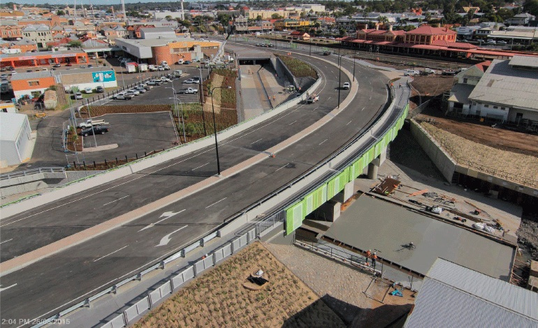
The $45 million Outer Circulating Road Victoria Street extension project had already been planned as a measure to improve traffic efficiency, but quickly evolved to deliver a number of flood mitigation benefits the city so desperately needed.
The project involved constructing a four-lane extension of Victoria Street, a new Gowrie Creek bridge, doubling the capacity of the Russell Street culvert structure on West Creek and upgrading of both the East and West Creek channels.
Designed by GHD, project management was carried out by Toowoomba Regional Council and constructed by Probuild Civil, with Harrison Infrastructure Group acting as superintendent.
The project presented significant technical and social challenges for Toowoomba Regional Council as the project is located at the confluence of the two creeks, which form part of the Gowrie Creek catchment whose waters eventually run into the Murray-Darling River system.
Working in these waterways provided a constant challenge for construction crews, with the site flooded on a number of occasions. One of the major challenges was the existing ground conditions. Most of the site – former railway land – was considered to be contaminated and had been adversely affected by the 2011 Toowoomba flood.
The project also had to contend with a live sewer system running along West Creek and extensive service relocations. Construction impacts, including lengthy road closures, required Council to consult extensively with city businesses and residents. Despite the considerable challenges, the Council delivered a landmark project for the city, both in terms of traffic efficiency and flood mitigation.
 Contractor asked Angela a few questions about the project.
How comprehensive were the enabling works required to operate on a constrained site?
Considerable early works at the site and adjacent areas involved the following:
• Demolition of an old petrol station building and decontamination of the site, including removal of underground abandoned
fuel tanks.
• Relocation of electrical infrastructure (high and low voltage and fibre optic lines) from above ground adjacent to the channel, to underground. This has improved the visual amenity and improved security of electrical supply for the CBD.
• Dismantling a heritage-listed toilet block, brick by brick, prior to construction. The bricks were placed in storage during the works and the toilet block was rebuilt in the same location after the adjacent culvert upgrade works were completed.
• Clearing rail tracks and old debris from contaminated land which was formerly Queensland Rail land to clear the way for construction of the four-lane roadway. An abandoned timber bridge on former Queensland Rail land also had to be demolished.
• Purchase of adjacent private property, and clearing adjacent sites for construction access.
What were the environmental controls used to allow removal of contaminated materials while ensuring the integrity of the creek? Similarly what environmental controls were used for the earthworks and construction activities?
Soil samples were taken from approximately 40 test holes prior to construction to identify contaminated areas.
Monitoring and testing of material as it was excavated determined the level of contaminant and location for disposal.
Extensive noise monitoring was undertaken around the construction site to help reduce the impacts on nearby businesses and residents. The project team closely monitored noise levels at an adjacent conference centre during university exams to ensure there were no disruptions to students.
What level of monitoring of historic buildings was required to protect against vibration induced damage?
During the design phase, geotechnical assessments of the zone of influence from piling works were used to identify any at-risk buildings. Condition assessments and dilapidation surveys were undertaken at buildings around the construction site before works started. As an added protection to buildings, vibration limits were placed on construction and vibration monitoring was carried out at key locations during works.
As a result of the protective measures undertaken and ongoing monitoring, there was no damage to buildings as a result of the project construction.
What was the level of protection for the historic buildings?
Dilapidation surveys were carried out to determine the pre-construction condition of historic buildings around the project site. Noise and vibration monitoring were carried out during the works and post-construction dilapidation surveys were undertaken after project completion to confirm that there had been no damage to the historic buildings. The heritage-listed Russell Street Men’s Toilet Block was carefully dismantled, placed in protective storage, and rebuilt on site by a specialist heritage masonry company.
It appears the project is in the CBD and represents a small construction site so planning using a systems approach may have been very important – how were the bridge beams transported and lifted into place?
The bridge beams were transported to site from Brisbane between the hours of 4am and 9am using a pre-approved route around the CBD to avoid traffic delays.
A total of 39 girders were placed as part of the three-span Gowrie Creek Bridge construction, ranging in size up to 32 metres in length.
The project team used a 400-tonne super lift crane to lift the girders. Assembling the crane itself was a huge task, which took about a week to complete. Some of the girders weighed more than 60 tonnes each.
Due to a lack of suitable area for onsite storage, the girders were lifted straight from the back of the truck on to the bridge.
Was a ‘systems’ engineering’ approach used to determine site logistics and to manage the construction activities and their interactions?
This was the contractor’s responsibility. The programme remained very flexible to cater for unanticipated difficulties encountered onsite, such as unrecorded services and abandoned pipes, and to allow for an overlap in the constrained work area.
How extensive was the flood mitigation works for the project?
The project area was devastated in the 2011 floods which were considered to be somewhere between a one in 300-year and one in 500-year flood event.
Flood mitigation works included duplicating the capacity of the Russell Street culvert structure on West Creek, constructing a covered structure along the creek to contain flood waters in the channel and widening and extensive upgrading of the West Creek channel itself.
The East Creek channel was widened and upgraded and a three-span Gowrie Creek Bridge was constructed over the confluence of the creeks.
A section of the channel north of the bridge was widened and lined with rock to reduce erosion.
These measures have provided significant flood mitigation benefits to businesses, residents and road users in the area.
What were the major risks associated with the work and how were these mitigated?
Several major risks were identified during the design phase of the project. A major risk was the need to work in two creek areas, which were subject to flooding at short notice. On a couple of occasions the entire project site was flooded due to the sheer volume of water in the creek systems.
High-level working platforms were constructed to improve safety, reduce risk and increase flexibility for construction crews. The project team used adjacent land to locate plant and equipment out of the water level at short notice.
The team also relied on Toowoomba Regional Council’s Flood Early Warning System to provide alerts when water levels began to rise in West and East Creeks.
The location of services also represented a major risk. The project team undertook extensive potholing and ground-penetrating radar to locate and verify known services.
However, due to former industrial uses of the land, there were more than 100 years of abandoned and formerly unidentified services.
The project manager ensured designers were on hand for construction fixes onsite. The project team also developed strong working relationships with services authorities for fast response as required.
How were live services located and then managed and how extensive/frequent was the need to remove or relocate services?
Magnetic and ground-penetrating radar were used to locate live services. Pothole vacuum excavation was also used to locate services in coordination with service authorities.
What difficulties were experienced in disposal of contaminated materials, distance to disposal site and any treatments required of those materials?
The project team liaised closely with Council’s waste management facility to ensure the efficient disposal of material. Much of the material from the site was able to be used as day cover at the waste management facility just north of Toowoomba.
Highly contaminated material was securely shipped to an Ipswich facility about 90 kilometres away.
Parting words from Jeremy Sole- a final column